Sunday, May 30, 2021

Daily Exercise Log: Sunday May 30th, 2021

I enjoy weightlifting as a supplement to running. I feel like I could probably do even better if I followed a consistent plan instead of just doing whatever I felt like each day, and writing this out on my blog might be a first step towards developing a more consistent routine. 

I also have this issue where, when I hit the weightroom, I want to do every single exercise I can think of, which isn't the best plan for building strength either. 

Today's workout was 5 sets each of:

* Barbell squats
* Dumbbell side lateral raises
* Barbell overhead press
* Neutral grip pullups

Another goal of mine is to do more core/ abdominal exercises as this is a weak point for me.

On my next weight room session, I think I'll try to do two different core exercises, plus more leg work, maybe lunges and deadlifts.

Hopefully I can begin to formulate a better plan that works with what I have available at home.

I also did an evening run tonight, Rock Island Trail, 8.0 miles on the dot. Had to run past the house at 7.97 and go a little up the block to complete it... you runners may know how that is. 😄

At Incline club we used to run around the park when returning if we only needed a little more mileage. 

Run tonight was good, a little slow, but that's because of overall mileage this week being high and also the 5 sets of squats earlier. I didn't feel totally bonked by the end, even though I slowed down. I hope the real ultra runner is built by going slow and surviving tough runs 🏃‍♂️! 

The trail is super green and everything is growing excellently.

The air was fresh after the rain today and no one was out. It was a little strange how quiet it was despite being Sunday night on a holiday weekend. In a typical year, this weekend would have been rowdy... but it's strangely quiet in Colorado Springs tonight. Makes me wonder if, despite many people adjusting to post-pandemic lives, more people have decided that going out wasn't as worthwhile as it used to be.

I'm certainly more of a homebody myself these days. A good run in fresh air is all I need to celebrate the holiday weekend!

Saturday, May 29, 2021

Daily Exercise Log: Saturday, May 29, 2021

I've decided I would like to keep track of my "normal" exercise days in a more dedicated way.

I do keep a paper running log, as I've mentioned previously, but it has limited space to record information. Sometimes you need a little bit larger forum in order to detail how you're feeling, energy levels, nagging aches and pains, etc. This way you can get ahead of injuries and avoid burnout.

I already use this blog to detail large adventures, but I plan to post more regularly about "normal" runs.

Today's run was 8.2 miles on the Rock Island Trail, east to Powers and back.

I'm still in recovery from my long effort on Monday, so I took it easy on my jog today.

I got a pre-dawn start at about 4:30 am, as astronomical twilight just came to an end and nautical twilight began. I love how early the sun comes up in the spring - astronomical twilight began at 3:43 am, so it was already getting light from way before I even started. With it being Memorial Day weekend, and Saturday, virtually no one was out - I had the trail all to myself in the holiday weekend quiet.

The air was cool and refreshing. Wearing a mask all the time was comfortable, even though no one was around. It kept the cold wind off my face, even as I wore shorts. Spring weather is the perfect time for shorts with long sleeve shirts and beanies - my favorite comfy run combo.

I noticed how absolutely green the Rock Island Trail is, showing how much water we've gotten in recent weeks. It is a relief to see Colorado so green, and I hope it will keep fire season at bay.


I noticed that they have now put signage up for the open valley off of the trail between Murray and Powers. This might be a city open space, but I don't know if it has a name. I'm glad they've begun adding more signage for trails throughout the city.

 Crest Trail to the left (runs on top of the old rail bed at the top of the hill), Crimson Trail to the right (runs along the valley below).


The wildflowers alongside the Rock Island Trail are pretty too!


I ran out to Powers, and turned around and came back. The way back felt stronger, I believe it is slightly downhill as you go west. All in all, a great way to start Memorial Day Weekend!!

I might decide to do a little bit of gym work later. Energy levels are decent today. 

Wednesday, May 26, 2021

Exploring the Vastness of the Deep Rampart Range

This past Monday was my first planned long adventure run of the year! Winter has been long; I can't believe it is almost June and this was just my first time to run in the true mountains since October. 

Spring has sprung in the Rockies!

I had a general idea of where I wanted to go and what I was looking for out of this run, but I set out with an open mind and anticipation of a little bit of unplanned exploring as well. What I ended up doing was a roughly 24 mile trail loop within the heart of the vast, deep Rampart Range. 

I started out from the south end of Greenland Open Space, using the New Santa Fe connector trail to pass through Palmer Lake, and connect to the Palmer Reservoir Trail.


The sun was just rising over Greenland Open Space as I started. The town of Palmer Lake lay ahead, and the mountains that I was heading towards. 

I entered the Palmer Reservoir Trail from the pedestrian-only gate, and began a gentle, smooth climb on a wide, gradual trail. This part of the trail reminded me of the beginning of the Cog tracks - the trail is actually fairly steep, but due to its even surface and wide appearance, it is relatively quick to ascend to the first reservoir.

The pedestrian gate and entrance to Palmer Reservoir Trail. 


Right after the first reservoir, after only about a mile from the pedestrian gate, I made the hairpin turn onto the Ice Cave Creek Trail. This trail was super fun!!


Palmer Reservoir #1

The Palmer Reservoir Trail is down on the left. When headed uphill, it's easy to miss the hairpin turn for the Ice Cave Creek Trail. 

The Ice Cave Creek Trail impressed me right from the start. Whoever established this trail did a great job. After a short but fairly steep segment that only lasts a tenth of a mile or so, the trail becomes very flat and feels almost slightly down hill. And in this part, the cool breeze blowing felt amazing! The temperature difference was stunning. It reminded me of Refrigerator Gultch in the Lost Creek Wilderness, which I ran through couple of summers back. It was cool and shady and had awesome stacked rocks (which would become a theme for the day.)

Creek crossing and stacked rocks on the Ice Cave Creek Trail.

Soon after a small creek crossing, I joined the Swank Trail, which immediately became a fairly steep single-track climb for the next mile. Important - if you are trying to stay on the Swank Trail, keep left at the Y-split with the Sundance Mountain Trail.

Keep left to stay on the Swank Trail; the right fork goes up Sundance Mountain Trail.

After approximately a mile of climbing, I came to another junction. I wasn't quite sure which way to turn at this point, so I decided to turn west and continue going uphill. This ended up being a great decision! I was on the Ice Cave Cliffs trail.

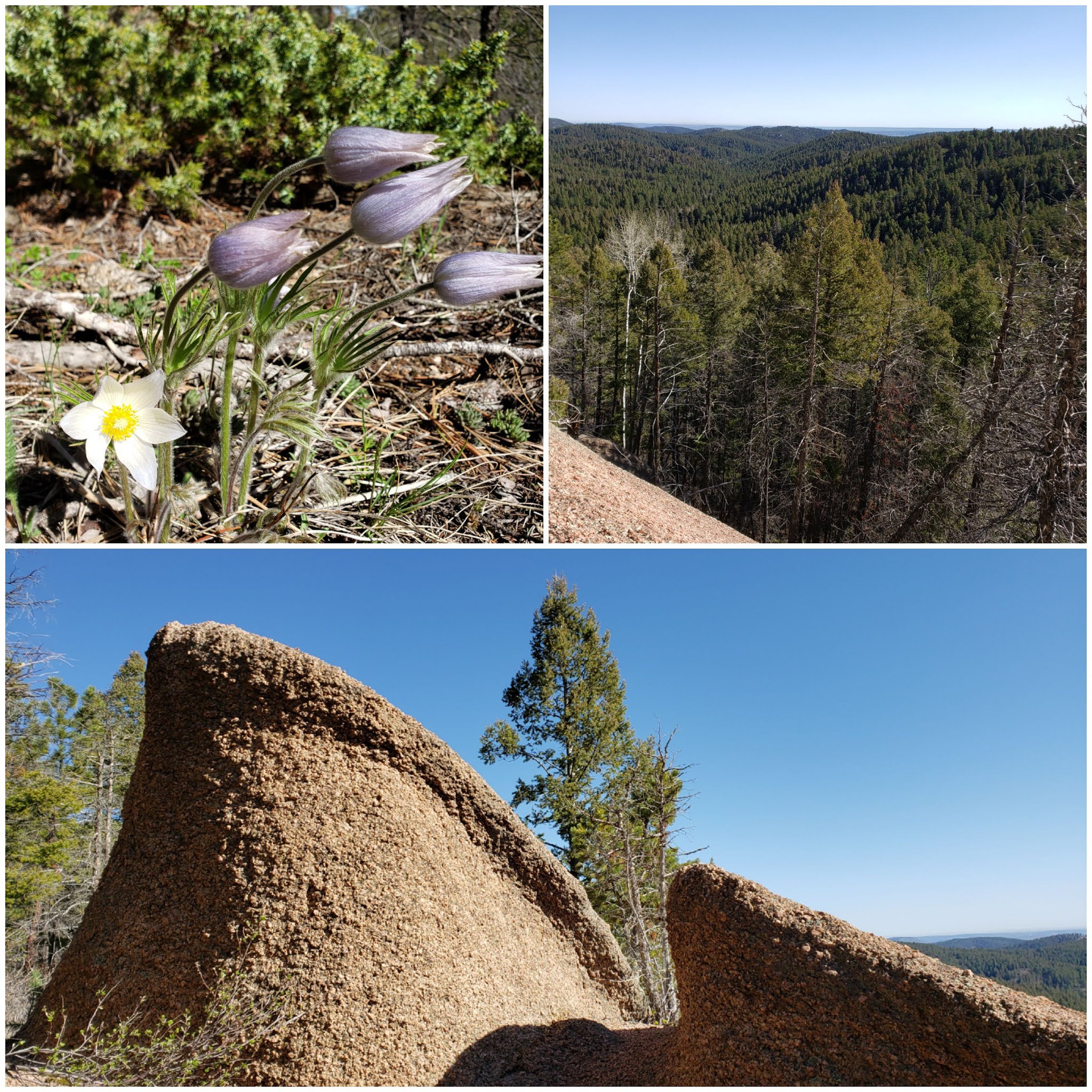
The trail became even steeper, about a class 2 climb. The views began to open up immediately. And the forest was decorated with these interesting flowers - purple and hairy on the outside of the petals, they opened up to be white flowers with yellow centers. If anyone has any information about what kind of wildflower this is, I'd be interested to know.


Interesting wildflowers, rocks, and open views at the beginning of the Ice Cave Cliffs Trail.

The Ice Cave Cliffs Trail was a short but steep segment that led up to a large rock formation. I climbed a small flat rock on the south side of the formation and found a jar with a hiker's logbook... and the view was STUNNING! 😍 


I sat atop the rock, in the bright Colorado sunlit day, and took in the vastness of the forest around me. Here I was, maybe four miles away from town, but deep in the heart of the Rampart Range. Stacked rock formations created small spiked summits all around me. I felt at peace in the wilderness. This is exactly what I was looking for!


Ice Cave Cliffs overlook panorama. 

Beyond the neat rock towers, I could see the aspen-filled valley on the back side of Mount Herman, where I had run through on my adventure last October, and on several previous runs as well. 

Even further beyond that, I had a picturesque panorama of Pikes Peak and Almagre, both still snow-capped.


Sights from the Ice Cave Cliffs Trail: twisted logs, bright green moss, and soaring overlooks.

Rock formations at Ice Cave Cliffs overlook.

Summit log in a jar, with the Mt. Herman aspen valley beyond (upper right hand corner).

Sharp rocks with Pikes Peak in the background. 

When I'd had my fill of views, I retreated back down the half-mile trail from the overlook and rejoined the Swank Trail. The descent from the overlook was steep in a couple of segments, reminding me of clambering around on Blodgett Peak. However, the steep parts didn't last long and were quite manageable. 

When I returned to the junction with the Swank Trail, I turned north and continued my meandering adventure. At this point, the Swank Trail begins a long steady descent. It was one of many ups and downs that the day would bring.  Soon I'd reached the Sidney Harrison Connector Trail, and I turned west once again.

This next part of the trail reminded me of Elk Park Trail on Pikes Peak. There were pretty little meadows with soft single-track.

Soft sunlit meadows on the Sidney Harrison Connector Trail. 

Climbing towards the Sidney Harrison Trail.


The trail climbed gradually towards the Sidney Harrison Trail. Soon I'd reached the junction, and the Sidney Harrison plane crash appeared soon after. 

The somber sight of the plane crash.

Memorial sign for Captain Sidney Harrison.


Soon after seeing the plane crash site, the forest became deeper and darker. Dead trees with notably twisted trunks appeared with increasing frequency. It became apparent that this was an old, deep part of the forest. It felt a little mystical, like a connection to our past. This part of the forest felt untouched, like it had been allowed to grow wild for many centuries.


Aspens with eyes 👀 and candycane-striped dead tree trunks were the signature markings of this deep part of the forest.

Moss-covered rocks in the deep forest.

The Sidney Harrison Trail was about 3 miles long, until I connected with the forest road #324 in the Rampart Range. I was getting a bit tired by this point, and I was glad to be on a wide dirt road for a little while. The only downside was that it was an ATV/ 4-wheel drive road, and it undulated quite a bit. I was never certain whether I was going to be losing or gaining elevation.

Now that I was more than halfway through a large loop, I was confident in the remainder of my route for the day. I would continue on FR #324 until the junction with the Winding Stairs Trail, and use this to go back to Palmer Reservoir Trail.

However, I was worried that I would miss the connection for the Winding Stairs, so I turned around a couple times and backtracked on small segments to investigate if I'd missed the junction. In the end, my worrying was for naught (except for bonus mileage) because the junction was obviously marked by a sign that said "No Motor Vehicles."

A cool rock formation that looked like a marshmallow Peep along FR #324, and also the ONLY patch of snow that I saw all day!

The junction of FR #324 and Winding Stairs Trail, looking back at the road after just entering the trail.

The Winding Stairs Trail was exactly as named. It wound like a snake, gradually descending, but not without a fair number of short uphills thrown in for good measure.

At times, the trail was wide like a doubletrack dirt road. At other times, it was difficult to distinguish the trail from a steep downhill wash. I saw a few strange sights, like circular moss growths on a rock that looked like petroglyphs, and a dead tree trunk with spikes on the *inside.* I began to feel like maybe I'd been out in the woods a bit too long!

Strange sights on the Winding Stairs Trail: circular lichens or moss on a rock, and a tree trunk with weird spikes inside.

Finally, after a steep downhill that involved a little bit of pathfinding, a view of the upper Palmer Reservoir came through the trees. I rejoiced! Almost there!

Palmer Reservoir #2 through the trees.

I descended the final bit of the Winding Stairs Trail and came back to the Palmer Reservoir Trail. The easy, wide, smooth downhill felt like a relief after the steep descent I'd just completed. I even clocked my second-fastest mile of the day (after mile 1, which I started off fast 😅 from excitement.)

Palmer Reservoir was pretty in the afternoon sun.

Nearing Palmer Reservoir on the Winding Stairs Connector Trail.

Upper Palmer Reservoir. 

I descended the remainder of the Reservoir Trail and came back to town, passing by the outside of the tracks on the far side of Palmer Lake (and avoiding all pedestrians this way), rejoining the New Santa Fe connector back to Greenland Open Space. What a day!

New Santa Fe connector trail (top) and the south side of Greenland Open Space (bottom).

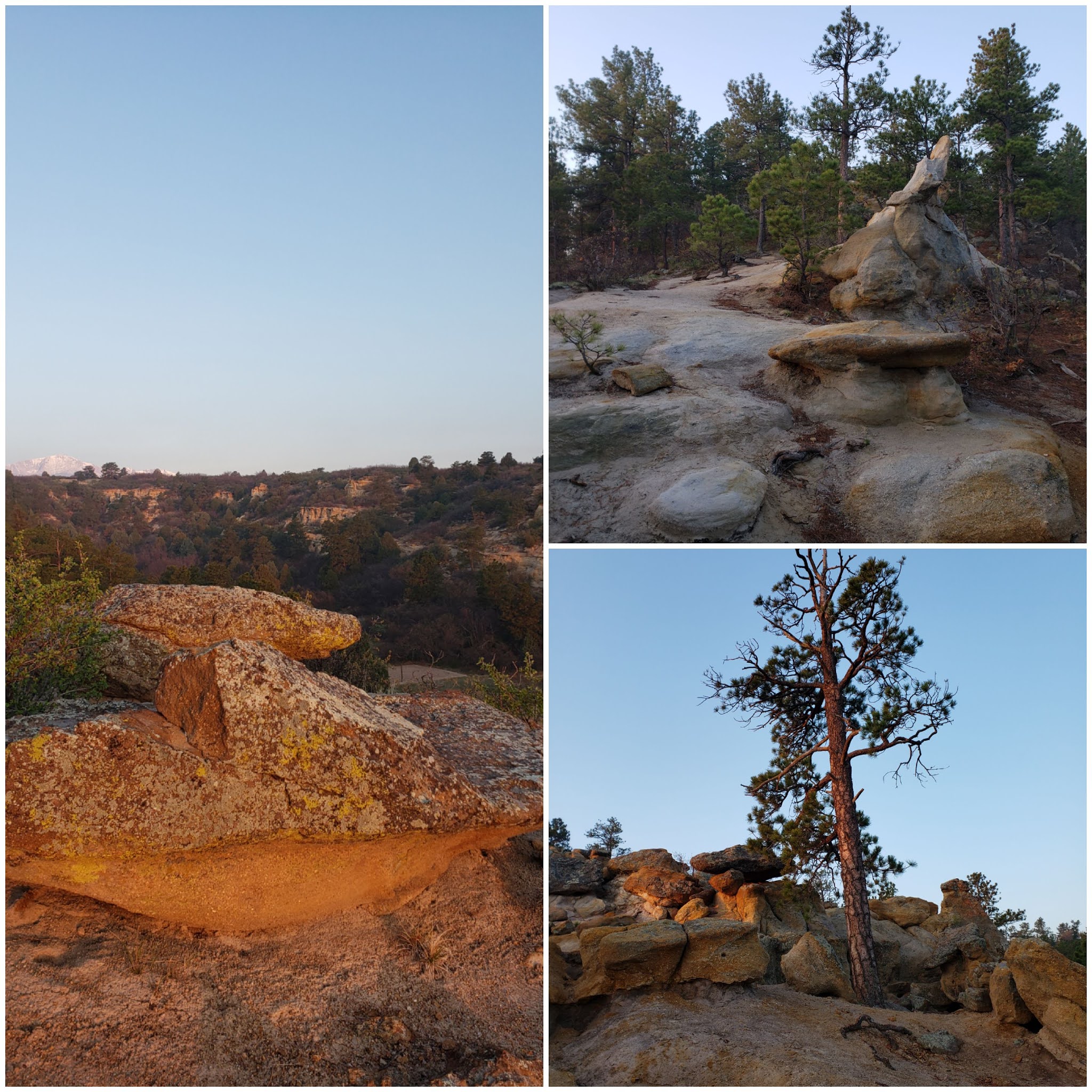
I took a peek back at the town of Palmer Lake and the mountains from where I'd just come, capping off my day just like I'd started it. 

From the early morning ascent into the deep wilderness, to the "naturally refrigerated" Ice Cave Creek Trail, to the sunlit wide views atop Ice Cave Cliffs overlook, to examining the site of the Sidney Harrison plane crash, to wandering through the untouched ancient forest - this was really an adventure to remember. It was food for my soul. If you've made it this far, thank you for reading and journeying along with me! ❤

View back at Palmer Lake from Greenland Open Space at the end of my day.

Now that it is almost summer, I can't wait for more adventures! See you all on the next one.


Sunday, May 16, 2021

Mid-May 2021 Update

Lately, I've only been updating monthly at the end of each month. But this month is moving along swiftly and I felt that I had enough to share in order to justify a mid-month update!

I haven't looked at the books and calculated my mileage for the month this far yet, but I have a sense that I'm right on track for getting between 140-150 miles this month, so just on track (or a little bit ahead) for my 2021 goal of 1700 miles this year.

I have a positive feeling about this summer! The weather is warming up and the outdoors are calling me! As many of you know, my husband has been extra cautious during the pandemic, to the extent that he wouldn't allow me to run outdoors in the neighborhood or go on regular runs for the last year, meaning a lot of overall treadmill mileage for me.

I stuck it out, but I really don't enjoy treadmills, and it's been a little bit like a year in prison when I couldn't just lace up and go for a run whenever.

Finally, a couple mornings ago, he gave me the go-ahead for an early morning jog in the outdoors. I finally feel free! I've been missing regular running so much. Just the ability to leave out my door and connect to the many wonderful local trails gives me optimism. I'm fully vaccinated and I still wear a mask when I run (a gaitor), but I got tired of sitting inside and being jealous of people walking their dogs outside because I was not allowed to simply go out of my door.

That said, I'll still make an effort to go outside when fewer people are out, meaning early mornings or later evenings, and I'll still not be allowed to go on highly populated trail runs like Barr trail or the Incline. But just the ability to be able to run is amazing.

As one of my first outdoor local adventures, I did a big loop around Palmer Park. Coming in on Greencrest trail from the far southeastern corner of the park, I climbed the eastern bluffs as the sun began to rise.

Rock formations near the eastern side of the park at sunrise.

Rock formations and wildflowers at sunrise.


The wildflowers are blooming in the park, decorating the ground with small splashes of pastel colors.

I followed Greencrest trail all the way along the eastern edge of the park until I reached the northeastern corner by Lazyland.

There was a small layer of low-laying fog in the northeastern valley. It was fresh and wonderful, and I breathed deeply in the forest air. This is what I'd been missing for the last year when I stuck (mostly) to the treadmill!


Low-laying fog in the northeastern valley.

I then followed the Lazyland trail for a short time until the connection with the Yucca trail.

The sun was shining its early morning golden rays in the area near Lazyland.

Sunbeam in the morning at Lazyland.

Rock formations near Lazyland in the morning golden rays.

I ascended and topped out the northern mesa of Palmer Park. I then followed the winding Yucca trail all the way until its connection with Templeton trail on the WEST side of the park. (Yucca trail has several connections with Templeton trail throughout the park.)

The view east, near the top of the mesa (Yucca trail.)

The view west from Yucca trail near the northwestern side of the park. Views of Garden of the Gods in the lower right corner, and a thin strip of clouds across the southern part of the mountains. 

I descended the winding trail on the west side of the northern mesa, adjoining Templeton trail for a short while, until the intersection with the Palmer Point trail. Another short descent, and then I was running through the beautiful field on the western side of the park.

Palmer Point trail along the western side of the park.

A view back at Pikes Peak from the Palmer Point trail near the stables. 

I wrapped up my run by exiting the park by the Mark Reyner stables, with a peek back at the peak, now fully lit in the bright Colorado bluebird day.

Total mileage for the run was 11.4 miles, including some extra miles during the warm-up and cool-down mileage from my house.

I have missed the simple joy of fresh air and morning sunlight!! I can't wait to do more lovely runs like this soon.

And hopefully, a big marathon-length challenge for me coming up soon (still in planning stages at the moment.)

Can't wait to do (and share) more!  See you all on the next adventure. 

Sunday, May 2, 2021

April 2021 Update

 Wow, April was actually a huge success! I ran 170 miles for the month. That's a huge improvement upon the first three months of the year, and it gives me a little bit of a jump start for the rest of the year.


I still did a bit of treadmill mileage, but my outdoor mileage is up. My husband is still too concerned with coronavirus to allow me to run on trails most of the time, despite being vaccinated and always wearing my mask!! The only exception is if we find a trail where no one is at the trailhead, which is rare.


But he has begun to allow me to run the very early shift around my local area before anyone is out and about. I try to wrap up my run before 5 am so I don't pass by anyone on the sidewalk.


But man, I'll take road and concrete at 3 am over the treadmill any day. And it has helped me increase my mileage to a level that I feel better about.


I *really* hope that this summer, my husband will feel that it is safe enough that I can go back out on the trails again (even if it's not the Incline.)


For now, I will keep chugging away on the sidewalks and staying consistent. Stay healthy, everyone!