Friday, July 29, 2022

Vegas vacation photo album

This isn't a typical blog post from me! The last week has been busy with helping my folks move back to Colorado from Arizona.

But on the way down to Phoenix, Alex and I traveled to Las Vegas first, and took a couple days to visit the sights and sounds of the city. 

I had such a blast walking the strip at night and seeing all the lights, then visiting Fremont Street as well!

The story of our travels (in photos):

I ran a last chance 10k in Palmer Park the afternoon/ evening before we departed. (Wednesday the 20th)

We traveled west on I-70 through western Colorado and watched the landscape change from high mountains to mesas.

I-70 west travels from Colorado through Utah, where we picked up the I-15, which cuts through the corner of Arizona before entering Nevada. 

We still wore our masks when we walked the strip, since it was pretty crowded as it was a Saturday.

Sunset on the Las Vegas strip.

Some cool Vegas landmarks. 

Saturday night on the strip! Just about as many cars below as pedestrians above.

Our last stop on the Vegas tour was Fremont Street. Very colorful!

After our night in Vegas, we continued on to Phoenix and spent a couple days moving my parents back here. That was enough of a workout within itself!

I finally got back to my regularly scheduled running routine, getting 7 miles (flat) on Thursday the 28th.

Now that I'm home, and the weather has cooled off a bit, I've got my sights set on some upcoming ultramarathon adventures! More soon!

Tuesday, July 19, 2022

Week of July 11th to July 18th, 2022

Monday, July 11th:

A lovely rest day, with a family walk in the evening of a couple miles at Spruce Meadows Open Space.

Another amazing Colorado sunset at Spruce Meadows Open Space with the family. 

I love this open space, it's one of the better-kept local secrets. 🤫 It consists of open high prairies and views of the surrounding mesas.

I've run the 8-mile loop around this open space a number of times in the past. The rolling prairie is a gentler run than the mountains, but just as pretty.

***

Tuesday, July 12th:

Machine pull-downs and machine chest press in today's weight session. Even with the equipment, I always try to go slow and really contract the muscles involved.

I followed up with 45 minutes on the exercise bike, at a casual speed.

***

Wednesday, July 13th:

Wow, an amazing afternoon/evening run!

Over 1700 feet elevation gain.

It was very hot at the outset, 91.3 degrees as the photo shows. But the overcast skies kept the punishing sun away; it was a great heat-training day. I like to incorporate some hot-day training runs, to feel comfortable keeping a steady pace in 90-degree heat.

I ran up Palmer Point trail along the west side of Palmer Park, connecting to Marconi Heights, then Austin Bluffs Open Space.

Overcast skies made 91-degree weather tolerable, even pleasant. Palmer Point (top & middle), and Marconi Heights (bottom). 

From Austin Bluffs Open Space, I ran out to the overlook. Sitting atop for a few minutes, I looked out towards the mountains. 

I visually mapped the rest of my route for today, and looked beyond, for a future upcoming run. I have in the works a 45-mile route that will trace what I did today, then continue north-westward to connect to Ute Valley Park, South Blodgett Peak, and up to Rampart Range Road. Then I'd descend all the way down to Balanced Rock before connecting back home through the Garden.

Today, I wanted to try out the connection to Ute Valley Park, from a trailhead I'd never been to before.

So I climbed down from the overlook and connected to the primary trail through Austin Bluffs Open Space, jogging west and bypassing the Windmill Project on UCCS, with Pulpit Rock in the background.

I kept on the trail and went through the student tunnel at University Village, linking into the Pikes Peak Greenway for a moment. I soon switched to sidewalks until ProRodeo Drive, where I would latch into the eastern Ute Valley Park trailhead.

I didn't even realize this trailhead existed until recently. On the Google map, it doesn't show that this trail is even part of Ute Valley, unless you zoom way in and you notice a small waypoint called "Ute Valley Parking and Hiking Trailhead 2."

When I arrived, the trail was marked "Black and Blue Loop." I entered this part of the trail just ahead of a couple cyclists.

The trail rolled up and down, along pine tree-lined trail. There were a couple neat rock formations, and then Blodgett Peak came into view through the trees.

Views from the overlook at Austin Bluffs Open Space (top); the Windmill Project with Pulpit Rock  behind (bottom); and the Black & Blue Loop looking towards Blodgett Peak (right).

When I do the 45-mile day, I'll continue on this trail through the main Ute Valley, all the way to the northwest corner, when I'll cross Centennial Blvd and quickly connect to the S. Blodgett trailhead.

But for today, I stuck to the Black & Blue Loop. I could hear the cyclists behind me. I was instantly enthusiastic. This was a fun challenge! Even though cycling is generally faster on flats and downhills, this trail had a number of somewhat rocky, albeit short, climbs. I would quickly drop the cyclists on the climbs.

I after I popped out of the Black & Blue Loop, I turned southwest on the trail toward Piñon Valley Park.

Here, the cyclists had taken a pause, and I asked them if they had been the ones just behind me since the trailhead. They said "yes, we almost caught you, but you were too steady." This was the biggest compliment I could have gotten!! My pace was so consistent that I had bested the "challenge" I'd set for myself to stay in the lead of the cyclists.

I took a last look to the trail that continued to the northwest, the route that I'll be taking when I head toward the Blodgett Peak portion of my 45-mile planned escapade.

Instead, I climbed on a trail - I believe it was actually named "Winding Woods Trail" - through the woods to the Piñon Park trail entrance. Then, I ran through the neighborhood for a short time, crossing Garden of the Gods Blvd and linking into the Sinton Trail, which I took back to the Pikes Peak Greenway and home. These trails will also make up a portion of my future big loop route, too.

With the long daylight hours, I was even able to make it home during the nautical twilight this evening, with bright yellow light still beaming from behind the Rampart Range. The orange-glowing moon was just beginning to rise. 

I accomplished over 17 miles in town today, and saw some new trail connections for the loop that I have planned 😀. I practiced jogging at a pace that I'd be able to do the whole 45-mile loop at, and it was just under 14 minutes per mile. Based upon this data, allowing myself some extra time for stops and photos and the major climb through the National Forest towards Ormes Peak, I think I would be able to do the 45-mile loop in about 12 hours. This gives me an average pace of around 16 minutes per mile.

Here is the planned route:


It might be a couple weeks before I have time to complete this route, but it's nice to have all the plans worked out! 😊 

***

Thursday, July 14th:

I noticed only mild sorness from the 17 miles yesterday. So I did the elliptical for a little while at an easy pace, just to loosen up, and ended up doing 2 hours and 15 minutes total, (with a few breaks!)

***

Friday, July 15th:

11 miles total today, split between two runs. I don't usually do "doubles," but that's just how it worked out today. First was a walk/jog of 5 miles, with a more consistently-paced 10k later on. Mostly flat today!! Also a few front raises, with only 10 lb weights.

***

Saturday, July 16th:

7 miles, mostly flat. This is shaping up to be a good week!

***

Sunday, July 17th:

Rest day.

***

Monday, July 18th:

Back to the trails for another solid 12-miler.

I wanted to pad my run with some extra mileage at the outset, heading out-and-back to Grandview Overlook on the road.

Then, it was all trail for the rest of the miles, heading down through Greencrest, up Marconi Heights, and back down the dirt road to UCCS where I joined the Tava Trail. I finally returned to Palmer Point Trail to wrap up my day.

12-miler on July 18th.

It was mostly overcast, but still fairly hot. No rain or drizzle this evening. I didn't bring water and felt fine the whole way, even 12 miles in 80-degree heat, so I think I'm adjusting to the hotter summer temperatures pretty well.

I feel like my weight is in a good spot, too. Not too bulky for the trails, but muscular enough to power up extensive climbs. I was sitting right at 139 lbs after returning from this run. 

This was a good, solid week. I'm really feeling confident about my upcoming long runs!!

I hope to be approaching the 40-mile distance soon. But first, I have to head out west to Arizona for a week or so. I'll be pretty busy, so I'm not sure if I'll be able to fit any running in, but we will see!

Monday, July 11, 2022

Week of July 3rd to July 10th, 2022

Sunday, July 3rd:

Gym day! Side lateral raises and kettlebell toe squats. Those toe squats sure do feel helpful for lower leg and even plantar strengthening.

***

Monday, July 4th:

My first run since my big one on the 30th. A midday recovery run of 10k. It was hot out, but windy enough that I didn't feel too overheated. But when I got back and stopped running, I felt like I was covered in a sheet of water. Warm day!


Also, since they closed the park to vehicles for the 4th, I had the run of the roads, which was nice.

***

Tuesday, July 5th:

We went with the kids to Elevenmile Reservoir, and walked about 3 miles around the lake. It was overcast but not too cold.

It was another lovely day that made me so thankful for living in this amazing state. There's so much beauty to see!


***

Wednesday, July 6th:

Full sets of barbell bicep curls first. Then, rotating pushups into planks. Basically, when I'd start to feel fatigued from the pushups, I'd go into a high plank and hold it for as long as I could. I didn't time them this session, just trying to stick it out until my abdominals felt like they couldn't take anymore. Also a good workout for the transverse abdominus.

***

Thursday, July 7th:

80 minutes on the elliptical. A nice cross-training day.

***

Friday, July 8th:

10.7 miles, beginning with a run up to the small hill along Palmer Point.

This small hill is actually a superb overlook spot. I looked for a minute to take it all in.

Up on top, I could see my whole world. It was peaceful, with distant storms over the far back side of Pikes Peak. The clouds weren't threatening and the birds were singing.

I could see parts of all my recent long run routes. Almagre, Mt. Rosa, and landmarks like Garden of the Gods, where I spent a fun summer working as park safety.

It was just a gorgeous evening to reflect for a few moments on everywhere I've been and how far I've come in this life.

Then, I climbed the northern mesa to the top of the park. At the top, I was treated to the most gorgeous sunset! Wherever they were, people had stopped along the trail to take it in.


Then I ran out to Grandview and back twice, watching the distant storms over the Rampart Range. The lightning was impressive!! As I wrapped up my run, the storm seemed to be slowly encroaching on the town, but I was already home safe, showered and relaxing 😎. 

***

Sunday, July 10th:

Over 8 miles in Palmer at sunset.


I was fascinated that, at the start time of astronomical twilight, the sky was still exceptionally bright. Although astronomical twilight is often indistinguishable from night in many cities, this evening the setting sun illuminated the clouds above the mountains. Interestingly, my phone camera couldn't pick up how bright it really was to the eyes.

Every sunset is unique 😍! I wish I could experience them all while running, but I love to see them when I can.

***

All in all, a nice week. No upcoming big runs on the menu quite yet, as I've got a few busy weeks ahead. But I have a few ideas 💡 kicking around for later in the month!

Tuesday, July 5, 2022

Storms on Middle Almagre

On Tuesday, June 28th, we took the family for a summer drive and tour through the Lost Creek and South Park areas.

We picnicked at Tarryall Reservoir and drove on Highway 77 all the way through to 285, taking in the sweeping views. What a lovely drive!


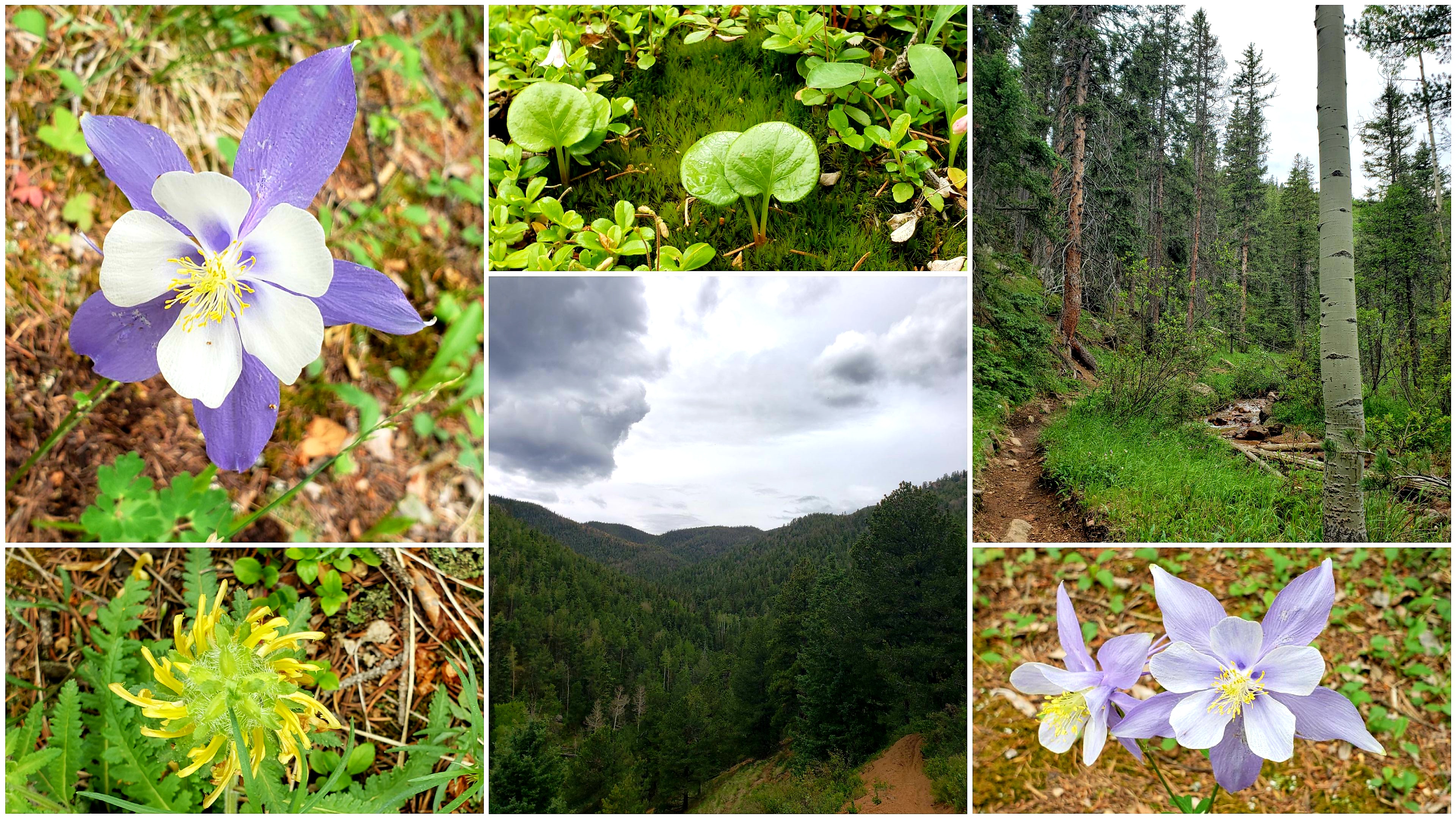
Then, on Thursday (the 30th), I was ready to go back to the mountains for another long one!!

My goal for the day was "Middle" Almagre. Almagre Mountain has north and south summits, both of which I've been atop in the past. But these summits are adorned with radio towers and human structures. Instead, I wanted to scale up one of the smaller sub-summits in between the north and south summits, and climb the tallest rock formation on top. It sounded more picturesque and natural. Unofficially, I call this "Middle" Almagre.

I began my day at the top of North Cheyenne Cañon, and headed up the Seven Bridges trail. It was fairly busy, up until the last bridge. After that point, the trail quickly became extremely quiet.

I made my way from 622 to 668, the Pipeline Trail. Clouds were building a little over my favorite valley. 

Soon I was back in the woods on my way towards Nelson's Camp, and I stopped paying attention to the sky, since the Colorado wildflowers were so abundant and amazing!

There they were, in every variety and color. And the columbines! The columbines were like purple little starbursts, popping up throughout the forest and along the main tributatory of N. Cheyenne Creek, which was still flowing quite well from the late-season snow.


At the old metal sign at the creek crossing, I turned west to follow the main flow of the creek, up towards the old Mt. Baldy Reservoir basin on top. This is the "standard" route up Almagre.

I've been on this trail many times in the past, and it used to be hard to follow in a few areas. But this was the first time I've been on this route this year, and the trail was very solid, easy to follow, and even carefully cairned at critical junctions.

Someone put in a lot of work to make this trail really nice!! I was so pleased that the trail was so easy to follow. The trail passed through a "bumpy" aspen forest and climbed beyond some steep crags.


Before I knew it, I was climbing close to the treeline and could see the Almagre Reservoir dam just ahead of me.

The view down into North Cheyenne Cañon and Colorado Springs beyond was filled with rain clouds, but it was dry where I was.


I reached the dam, and the alpine tundra. The tundra was filled with amazing wildflowers of all colors! It was impressive! Even the mosses were blooming.


The sky was cloudy, but it wasn't stormy or raining, and the flat, empty reservoir basin was calm and not very windy, with intermittent sunlight. 

I headed directly for the Middle Almagre summit. As soon as I climbed up to the ridgeline, a powerful gust of wind hit me.

I could see the South Slopes Rec Area a thousand feet below me to the west, with the Crestones and other distant 14ers decorating the western skyline.

As I scrambled up the short final ridgeline, Pikes Peak came into view, with a light green tint on its southern face, which I knew was actually a soft carpet of alpine grass.


I spotted the summit outcrop, and found that it was simple to get on top. It wouldn't even call it a "scramble" - more like a step-up!

From the summit of Middle Almagre, I could see a fantastic 360-degree panorama! There were some heavy rainstorms over the Westcliffe area to the southwest. But the most dramatic clouds were building over Bull Park, just on the other side of the South Slopes lakes.

"Middle Almagre" summit panorama. 

I sat on the top of the summit outcrop for as long as I could stand the wind. I loved looking at the views of the distant 14ers, with no smog or smoke in the air today.

Reluctantly, I decided it was time to descend and begin my return trip. I downscrambled the short ridgeline back to the Almagre Reservoir basin. As soon as I reached the basin, the sky crackled loudly. Lightning erupted and struck somewhere over by Bull Park, just to my northwest.

I had pushed my luck with the building storms. Now I had to get off this mountain, and fast. Adrenaline surged, and I ran downhill on the road 379A. This was the fastest way to escape back to treeline.

A cold spitting rain began, chilling me. But my pace to the south was faster than the storm encroaching from the north, and I quickly emerged from the rain. I slowed from my downhill sprint, and took a few more photos of the wide view down into North Cheyenne Cañon, and Mount Rosa to the south.


But the storm wasn't done with me. At the junction of road 379 and the 4-wheel road 370.C, the rain had returned, soaking me and chilling me to the bone. I sheltered under a tree for a moment, but the cracking thunder told me I hadn't much time to hesitate. I opted to continue to the south, following the 370.C road for a quick descent to Gold Camp Road, although I knew it would add some mileage to my day.

I just had to get off this mountain quick, and it turned out that 370.C was the perfect way to do that. The rock-strewn road descends sharply through thick forest. 

Soon, the storm began to dissipate, and the electricity gave way to a gentle pitter-pattering of drizzle. I was rock-hopping with a fresh energy, and my fear had evolved to joy. I loved this road! It was like a hidden gem, with views of Mount Big Chief to the east, and unique rock pinnacles to the west.


Soon I'd reached Gold Camp Road, although a few miles further away from town than my usual descent route. But I was certain now that I'd picked the right way to go, as the storm had nearly cleared, it was no longer raining, and the birds were singing all around me.

I began my long journey back to town now, with at least another 14 miles to go. However, it was all easy dirt road mileage, and totally doable. My confidence was up from last time I'd done this road run. All I had to do was put in the work!


I enjoyed the green valleys and the craggy rock formations - "old gods" that stood tall, made of Pikes Peak granite, watching over these mountains.

I felt good overall during the whole way back to town. Maybe I'm getting used to the ultra long road runs! Hopefully that means I'll be able to succeed in the Silver Rush 50 miler someday, which is one of my long-term goal races. I believe it has a decent portion of high altitude dirt road running. 


When I finally got back to town and finished, my distance exceeded 27 miles. A nice total for a crazy day! And, even though I'd had to escape from the lightning above treeline, I'd had an amazing day and made my summit goal.

It's been shaping up to be a great summer so far, training-wise! Soon, I hope to do a 40-miler and then eventually go for the 50-mile, which is my main goal for the year 😀. The training has been helping to build my mental long-distance fortitude, but I'm still a bit anxious about attempting the big distance.

This big Almagre day was a good one for me though! Hope that you enjoyed the photos and journeying with me.