Thursday, September 30, 2021

Seeking gorgeous Colorado fall colors on the Tenney Crags

Today (Wednesday, September 29th, 2021), I set out in the late morning from the base of Bear Creek Canyon with the goal in mind of seeing some fall foliage.  

The day was cool from the outset, and I knew storms were possible later in the afternoon. 

But the sun was shining as I quickly climbed the wide, smoothly-graded High Drive.

The first colors I saw were deep red ground flora, like a painter splashed red dots all the way up the hillside, less than a mile from the start. (Near the Section 16 loop connection.)

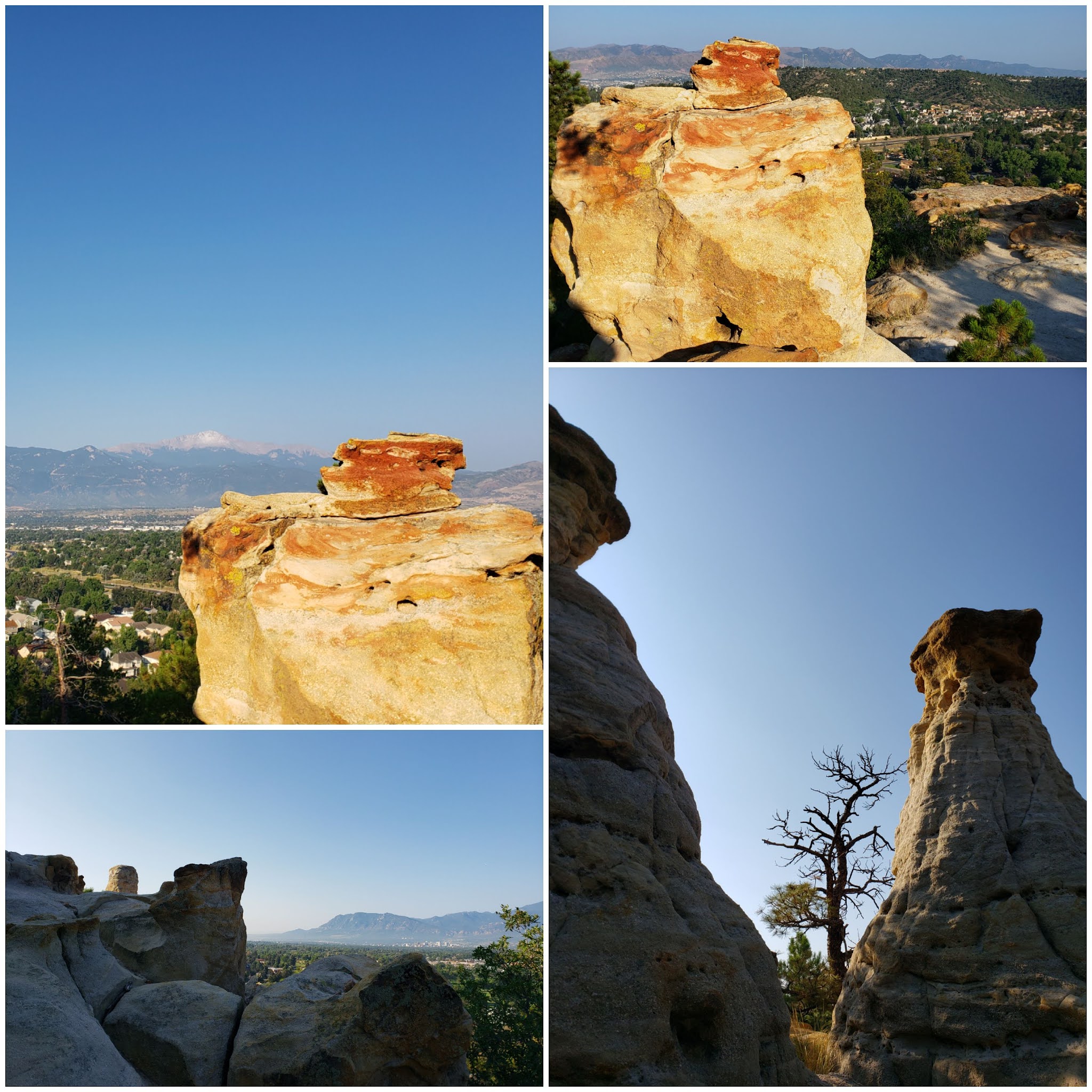
I could see blue skies above Specimen Rock.

Top: Red leaves on the hillside. Bottom: Specimen Rock is a prominent formation that is easily spotted and recognized from town.

Although I had an idea of which direction I wanted to go, I did not have a set plan or route for the day. Usually when I head to the mountains, I have a goal or destination in mind... but sometimes I like to let the day take me where it wants to. I just wanted to find beauty and perhaps get a decent workout while I was at it! 

I took Bear Creek Canyon Trail (#666) at the split, rather than continue on High Drive.

I ascended the open section of trail and came to the "dead end" where the trail is re-routed for the Kineo Mountain bypass. In his blog a while back, Jim had mentioned that there was quite a distance of sticks and branches placed in the path at this point by the forest service, perhaps for a quarter mile or so.

Well, some nice folks (or decommissioned-trail-invading monsters, depending upon how you look at it) went to great lengths to saw through a lot of the branches and trees, and the trail was quite easily navigable now.

It was on the decommissioned section that the colors really began to show.


Since I was in Bear Creek Canyon, where I'd been many a time before while it was officially open, I decided to do a route that I'd always wanted to do, but never got around to: Tenney Crags Trail.

I remembered reading quite a while ago on SummitPost that there *was* a trail leading up to Tenney Crags, *if* you could find it.

As I kept climbing up the canyon and passed the lovely falls, I figured I must have missed the Tenney Crags split by now, and I'd be best off just scrambling up the slope. (It could have just been an excuse to go off-trail climbing, one of my favorite things!)

I ascended a fairly steep slope, but not too difficult compared to some I've done in the past. It was pretty straightforward climbing, with small scree patches connected by woodsy sections and rock patches.

I soon came to the base of a cool-looking rock outcropping, with a great view to the west and the valley below Almagre Mountain.


It was about this time that it started hailing.

Ok, well it was actually one of my new favorite words - graupel. Although graupel is also called "soft hail," I don't buy that. It still hurt.

I tucked myself behind the rock outcropping for a few minutes and ate a snack while I waited for the weather to pass.

Luckily it was just a small patch, and it passed quickly. But now all the rocks were wet, and I wasn't quite sure of the best route to navigate to the actual summit of Tenney Crags, since I wasn't on-trail.

I figured I'd go around the hillside to the west and continue in a northerly direction towards the summit, and hope that I could find the actual trail on the way down.

That *sounded* like a good idea. But the west slope was filled with rocks and spiky little bushes. So many spiky bushes!

In fact, I had to downclimb the slope a little bit, a few separate times, in order to find a way through. On about my third short downclimb, I looked at my GPS and considered just throwing in the towel and downclimbing all the way to the creek and heading back.

But I convinced myself that the summit would be worth it, and pushed onward.

And I'm glad I did - because it wasn't much longer before I ran into a HUGE trail cairn.

YES!! The real Tenney Crags Trail! I could follow it to the summit now, and then on the way down, I could find where it connected to Bear Creek Canyon Trail so I'd know for next time.

The Tenney Crags Trail was really well marked. A cairn at every turn, and always one within sight.

Top left: The first cairn I came across. Bottom left: the gentle, well-marked Tenney Crags Trail. 

The trail meandered gently up the north side of the Tenney Crags summit, not even requiring any scrambling at all. And suddenly I was on top!

And what an impressive view!

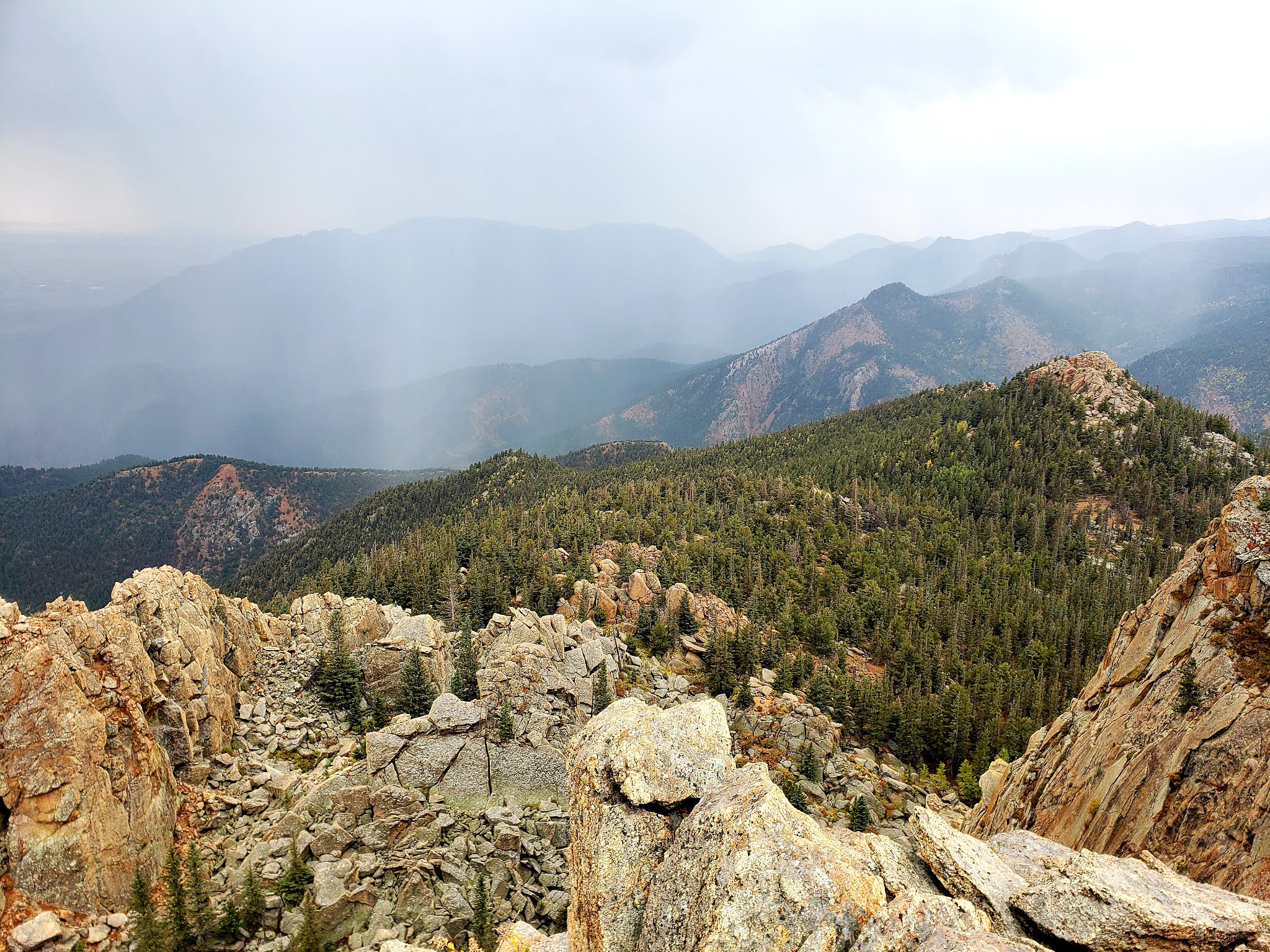
Tenney Crags summit panorama. 

To the south was a huge crag with the storms in the mountains beyond.


To the southeast, Cheyenne Mountain with rain streaks.


To the west, Almagre Mountain lurks in the background, with Mt. Rosa featured prominently to the left, and the slopes leading up to Mt. Garfield and Mt. Arthur in the foreground. 


Down to the east, storm clouds engulfed Colorado Springs, and to the north I could see the Blodgett and Ormes ridgeline, also streaked with rain.

But I just loved the view to the south! The steep cliffs and jagged rocks were what I came up here for.


However, shortly after the photo above was taken, a huge bolt of lightning struck in the valley below, and the thunder was instant. The graupel had made a return as well. And I was extemely exposed.

Time to go!

I safely descended back into the forest on the gentle trail, and was even able to jog at a pretty decent clip, following the cairns on my way down.

I was able to follow the trail all the way through to the drainage, no scrambling necessary. Of course, the graupel receded again and the sun came out. Colorado weather!

When I finally reached the Bear Creek Canyon Trail, I looked at my GPS and saw that I had been really close, like not more than a few meters away, from the actual trail. That whole scramble part of my journey had been essentially unnecessary, had I known the trail was literally around the next bend. But I guess I wouldn't take it back, anyway. A nice steep slope scramble is decent training.

I decided to go up towards Jones Park on trail #666 until I could cut over to #667 and then take the "legal" route back down.

And immediately upon coming into the Jones Park area, I was stunned by the best fall colors of the day!

All the aspens and grasses were really showing off. The colors were popping!


Every bend and turn in the trail was the most beautiful yet.

The gorgeous yellow meadow was impressive due to the high amount of rain we had this spring and summer. I remembered how bright green the grassy meadows were, only a few short weeks ago. (Here is a link to the Mt. Rosa/ FS 381 run I did, which has an example photo of these same grasses being a stunning green color.)

I eventually had to leave the lovely meadow, cross Bear Creek, and make my return.

As I descended trail #667, the rolling Captain Jack's trail, big thick clouds rolled in over St. Peter's Dome to the south.


I decided to take the Mt. Buckhorn trail, continuing on 667 until its junction with High Drive. 


It may seem strange, but I actually like the gray, stormy, desolate feeling of a cloudy day on Mt. Buckhorn.

When I got to the High Drive saddle, I felt quite good energy-wise and in my legs. I cruised down easily on the dirt road. It makes me happy to have enough energy at the end of a run to actually enjoy the downhill that I earned! πŸ™ƒ 

This run had a little bit of everything. Scrambling, new trail discovery, views, graupel, smooth downhill, but most of all - those fall colors that we all enjoy to see at this time of year. 

I got a little over 14 miles and 4500 feet elevation gain on this one. In the short-term, I need to get a couple good gym days in (I've neglected the gym for the last week at least - it's way too easy to let it slip by the wayside with so much else to do in this season.) We are also planning on going on a drive and walk with the kids soon, to catch some more colorful leaves. And if it works out, I hope to get one more mountain run in before the leaves fall off, possibly in the Mt. Herman area.

Thanks for following along πŸ˜€, and I hope you all are enjoying this season as well! Time to settle down with a decaf pumpkin spice latte, isn't it?

Friday, September 17, 2021

The many faces of Almagre Mountain

Almagre is a large, broad mountain with two summits and the reservoir basin between them. It has many faces, many trails surrounding it, and many ways to claim its summits. Some of which are:

1. The "standard" route which ascends the east side of the mountain. (Link to a detailed description of this route with photos, from my ascent in June 2019.)

2. The "road" route which follows the 4-wheel road to the summit, starting from Gold Camp Road. (Link to this route, completed in June 2018.)

3. The northern ridge route, which approaches from the north side. (Link to this route, from last month, August 2021.)

4. The southern gully route, which I explored yesterday (Thursday, September 16th, 2021) climbs to the south summit directly from the south face of the mountain.

Let me begin by stating, my initial goal when I set out in the morning was not Almagre, but to ascend to Bull Park on FS 376A. However, by the time I was rounding the bend on 379, I was running out of energy, and I realized I still had about 5 miles until Bull Park. I didn't feel that I had enough energy to do that, so I made an impromptu change of plans. Climbing steep scree slopes is kind of my forte, so I opted to claim the south summit of Almagre this time.

But allow me to back up for a minute, and describe the whole trip from start to finish.

I started out extra early for this time of year, a little after 6 am, and just as civil twilight began. By the time I had ascended all seven bridges on trail 622, the sun was up and the golden morning light was illuminating Undine Falls.


I continued onto trail 668, as the sun came up and shone across the valley.


This part of my route followed the Ring the Peak Trail, which is the almost-complete 62-mile circumnavigation of Pikes Peak. I continued on 668 to the junction with 701, and then followed 701 until it meets with the road FS 379 at Frosty's Park.

From Frosty's Park, I followed FS 379 as it twists through the mountains, westbound.

It was at Deer Park and about 8 or 9 miles into my journey when I started to feel the tiredness creeping in. I hadn't slept well, and while I can sometimes work with that, I didn't want to have to push another 5 miles outbound AND back, adding 10 miles to my day (my anticipated total would be 27 or 28 miles then.) Instead, I looked up at the sandy scree gully that I knew was the south slope of Almagre South.

It looked inviting. It looked comfortable. It looked like a short climb to treeline and the summit not far beyond. Moreover, it looked like a ton of fun, a lot of climbing condensed into a short distance.

I got onto the slope and found it to be rather easy. It was probably about as steep as the Incline, and very grippy scree. I could see from my COTREX app that it was only about 1000 feet up or less, which is only like a third of the Incline! The scree slope itself was shorter than that, maybe a few hundred feet, and then it broke out into a soft alpine meadow.

I could see Deer Park and Elk Park down below.


From here, I rounded the mountain from the south side to the east, and climbed up a small ridge to pop out into a huge, wide alpine meadow just south of the official south summit.

The south slope of Almagre is quite different from its other faces.

Immediately I noticed how sharp-shaped the rock formations on this side of the mountain are. The rocks here are VERY different from those on the mountain's north face.

The rocks here were huge chunks of solid Pikes Peak granite, cut at sharp angles and rolled down the hillside through the meadow. This differs significantly from the north ridge where I was less than a month ago, where the rocks are conglomerates, smoothed and weathered into visually appealing shapes by the forces of nature.

Not that these rocks weren't visually appealing - this part of the alpine tundra was absolutely gorgeous. But the dramatic rocks, combined with a sharp wind once I crested the ridgeline, wasn't welcoming. It was reminding me again, that I was but a visitor in this alien landscape.

This strange rock was like a cube, stuck to another rock.

I easily crossed the windy meadow and topped out the official south summit of Almagre.

The summit panorama was grand. I could see where I'd come from towards the east. In the center, the road 376A, Bull Park, and Sheep Mountain attracted my attention. To the northwest, the summit of Pikes Peak stood boldly. Outlining my view, and all the way down the grassy south slope, was all those solid rocks of Pikes Peak granite.

Almagre South summit panorama. 

I walked around the satellite radio tower, and began my descent. I would plan to descend the road 379A rather than the scree slope, opting for an easier, if slightly longer, voyage down.

On the way down, all of Colorado Springs came into view. How stunning! I could see all of the Black Forest to the north and downtown in the center. I could even see the bluffs that made up Palmer Park, where I'd spent so many hours trail running. They were so tiny and bitty looking from way up here!


I still felt pretty tired on my descent, but I felt fulfilled. I'd gotten what I had set out to get from the day.

At least, for the most part - I had hoped to catch some fall colors, but it was too early for the aspens in this part of the state. Southern Colorado won't have peak colors on our aspens until the first week of October, so I knew it was a little early. I did spot two aspens, way off in the distance, with my binoculars, that had turned bright yellow.

By the time I'd gotten back to the Seven Bridges trail, I saw some of the ground foliage that had yellowed slightly (which I must have missed on my way up since it was still pretty dark in the canyon at my start time.)


But still, the breathtaking autumn colors will have to wait for the next long one!!

Overall, what a day. I can now say I've ascended Almagre from four different routes. (I've also descended the slope to the west, so I've seen many of her faces.) She is a mountain of many moods, and multiple geological stories. What a fascinating playground, a place of wonder. A trip like this makes me feel small in a world so grand.

I ended up with 19 miles today, and 6000 feet elevation. Not a bad total, considering how tired I knew I'd be on this one. Every once in a while, it's not so bad to push yourself when you're a little fatigued or not fully rested - if nothing else but for the mental strength it generates.

But I'll try to be a little better rested for the next one!

Saturday, September 11, 2021

Another smoky week along the Southern Front Range

Saturday, September 4th, 2021:

A rest day after my 28 mile Mt. Rosa loop yesterday. 

***

Sunday, September 5th, 2021:

Home gym day with barbell overhead presses (a favorite exercise of mine, make sure to engage the core), dumbbell press-outs, and leg raises on the captain's chair.

***

Monday, September 6th, 2021:

Early morning jog before the smoke came in too badly. First I went up to Palmer Park and jogged up West Cheyenne Trail to Grandview Overlook. I was treated with great views of all the balloons lifting off from Memorial Park for the Labor Day Lift-Off!

Might be tough to see with the level of photo compression on the blog, but there's dozens of balloons dotting the sky.

A slightly more zoomed-in photo of all the 🎈 balloons! So cool.

I then descended the road, connected to Greencrest Trail, ran west along Austin Bluffs to Union Meadows Open Space until its north end near Collegiate Dr, crossing Union and running up Collegiate Dr to Austin Bluffs Open Space. I went out to the overlook at Austin Bluffs. 

View from Austin Bluffs.

I spent a few minutes on top, looking at the clear view of the mountains without haze. It was a great day and a good perspective to see the whole Pikes Peak Massif. I had my small binoculars with me, and peered at Mt. Rosa and Almagre. I looked up at Blodgett and Lone Pine, where I may yet go on an adventure before the season is over.

Then I descended to UCCS and ran all the way through campus back to the intersection of Austin Bluffs and Union before going home along the Templeton Gap Spillway.

The day's total was over 15 miles, and over 1700 feet elevation. And a little faster than 12 minutes per mile, which is good for a slow runner like me, especially just a few days after my 28-mile adventure.

***

Tuesday, September 7th, 2021:

Today's home gym workout was kettlebell lunges and standing dumbell chest flies, followed up by lying leg raises. (Lay on a yoga mat, straighten your legs, engage the core and raise and lower without completely dropping your legs. Great core workout!)

Then, a casual hour on the exercise bike, just for a little cardio. I didn't plan it this way, but got to watch a livestream of Courtney Dauwalter talking about her UTMB win while riding the bike. What an inspiration!

***

Wednesday, September 8th, 2021:

A very smoky day. I woke up to find that it was not a good day to run due to the air quality. It's days like this that I'm extra thankful for the garage gym. Dumbell front raises, then an hour and five minutes on the exercise bike.

***

Thursday, September 9th, 2021:

Rest day. Still tons of smoke outside. I usually plan to use the garage gym most days like this, but some days get too busy. That's why I prefer to let rest days fall on those days where life gets in the way of regular exercise, rather than scheduling rest days. (Except for the day after a really long effort, which I'll typically try to take off.)

***

Friday, September 10th, 2021:

The day was a little hazy, but better than the last few days. Near the evening, the winds changed a little and the air quality forecast was posted as "good."

I took the opportunity for an evening run. I did a loop, mostly pavement, with a short trail section. Total was almost 11 miles with over 900 feet elevation.

***

Saturday, September 11th, 2021:

We took a nice afternoon drive, getting out of the heat of the day.

The afternoon drive turned into an evening walk at a nicely forested little trail near Elizabeth. 


The forest is similar in nature to the Black Forest, with fresh pine air and a cool breeze.

I may yet do some gym work either tonight or tomorrow morning, but I'm taking it pretty easy this weekend, because I may try to run in the mountains on Monday before the week gets too busy!

Saturday, September 4, 2021

Mt. Rosa: The BIG Loop

Happy Labor Day weekend, everyone!

I set out Friday morning to get up Mt. Rosa. Since my last unsuccessful summit, I figured I still had unfinished business with the mountain.

To be clear, I've been up Mt. Rosa about a half dozen times in previous years, but not since the pandemic began. It was time to revisit those slopes.

Alex dropped me off at the top of North Cheyenne CaΓ±on. It was a quiet Friday morning, with only a handful of cars in the lot, especially since it was the start of a long weekend. 

My plan was to ascend the classic route, up St. Mary's Falls Trail.


The morning was cool and refreshing. It had just finished raining and storming the night before. The trails weren't dusty and had good traction from the moisture.

Even from the start, some clouds began building in the east.

Steep steps on St. Mary's Falls Trail, and views.

Above the Falls, as the trail continues towards Mt. Rosa, I noticed some clouds off in the distance building over the mountains. There had been a clear view over Mt. Rosa on our way over to the CaΓ±on.

Clouds to the east, and flora on the trail.

Clouds to the west along the trail.

I pressed on as the trail ascended towards the junction with 381.

The moss along the trail was abundant, and the most stunning color of neon green! More evidence of the wet spring and summer we've had along the southern Front Range. 

Bright green moss!

I crossed 381 and ascended toward the wide, flat saddle to the north of Mt. Rosa. As soon as I reached the saddle, I was entirely and completely engulfed in the fog.

With another mile or so to the official summit, I almost debated just turning around then and continuing on my loop, knowing that I wouldn't have any views at the summit. But since I didn't make the summit last time, and since trail runners don't give up that easily πŸ˜‰, I continued on anyway.

Scenes from the saddle and summit of Mt. Rosa. All foggy!

I took a little time at the summit, refueled and called Alex. By the way, reception up there is amazing - I had five bars! But the clouds failed to clear by the time I was ready to continue, so no summit views for me this time. (That's just a reason to do Mt. Rosa again!)

It was chilly in the fog on the Rosa summit, and I was glad I had my jacket. In fact, my hands started to get cold and I felt like gloves may have been beneficial, but I knew I'd be down out of the cold pretty soon.

I descended from the saddle to the trail #672 split, and took the fork to the west. Even though I'd already been on the mountaintop and the highest elevation point of my run, I was still very early on in the total mileage I'd expected to do.

Trail #672 towards Frosty's Park was somewhat washed out, rocky, and rutted at points. This meant a little slower descent.

Descending Trail #672 towards Frosty's Park. 

But once I reached Frosty's Park and began descending the road, I felt great and I was flying downhill!

Of course, at this point the Mt. Rosa summit was clear. I was only 50 minutes removed from the top, but too far to go back up this time.

I took trail #626, called "Frosty's Shortcut," back towards FS 381.

Top left: "Frosty's Shortcut" trail. Top right: The summit of Mt. Rosa shows itself from Frosty's Park. 

From FS 381, I descended past the closed Wayne's Campground, and joined Gold Camp Road for a fast and smooth downhill on the dirt road. It felt great to be going downhill at such a nice pace on a surface that wasn't hard on my legs. I think downhill dirt road running is just about the best there is. What a treat!

Views near the St. Peter's Dome trail.

It was no time before I reached the parking area for St. Peter's Dome.

I knew from previous experience that there is a dirt bike trail that connects directly from here, back down to the closed-to-cars section of Gold Camp.

I took this shortcut back down, and reconnected to Gold Camp just before Tunnel #5.


As I continued my joyous jog down the wide, comfortable road, I peered up at the now totally clear Mt. Rosa. Oh how she'd evaded me today!

I noticed something I'd never seen before, that you can actually see the top of St. Mary's Falls from just after the tunnel. I took out my binoculars (which I had packed for the summit views that never materialized) for a look.

As I continued down the dirt road, I saw the sweeping views of Cookstove Mountain come into the picture. The huge rocky cliff face is so attractive to me. It's one of those mountains that I'd like to sit on top of some day.

I've actually *almost* made the summit of Cookstove once before, but it was one of those days with intermittent rain and hail that tried to chase me off the mountain. I looked at Cookstove Mountain and thought "maybe next time!"

The views back towards St. Peter's Dome were quite nice as well.

Top: Mt. Rosa, now totally clear of clouds, is the peak in the left-background. Middle: Cookstove Mountain, (a someday goal). Bottom: St. Peter's Dome on the left, standing boldly. 

After a few more miles, I was nearing the parking area where I'd started this morning when Alex dropped me off.

I passed a hiker wearing a teal-colored N95 mask and waved to him. For context, I always bring a face mask when I'm running, and I pull it up when I'm passing folks, especially in popular areas, as a courtesy to others. This hiker commented on how he was surprised to see a runner with a mask on, and how he thought he was the only one. I then explained I wear it when I'm around crowds especially, but I'd been up Mt. Rosa today and I'd had the mountains to myself. He clearly had a good knowledge of the area and asked about my route. I explained that I'd gone from Mt. Rosa, down to Frosty's Park and then down Gold Camp, and he was impressed. I told him I was about 20 miles deep at the moment, but that I would go for the full marathon today. 

The interaction buoyed me so much that I felt the heaviness in my legs lifting, and my pace increased. In fact, my fastest mile was in mile 23.

After the parking area, I continued down Gold Camp still, taking advantage of the fast, smooth downhill miles. Sometimes it's nice to "cheat" and finish at a lower altitude than you started. 🀫

I ran down past Bear Creek Canyon, and met Alex for my ride home near Bear Creek Park off of Lower Gold Camp.


I was even able to add an extra mile of jogging around the parking lot as I waited for my ride, bringing my total to 28 miles for the day, and over 5000 feet of elevation gain!

This was a feel-good day. The trails were straightforward and there was minimal scrambling, as compared to my last long one which had a huge scramble. Running downhill on dirt roads is a nice confidence booster. And this kind of training is great for the Leadville Silver Rush 50, which is a goal race for me once COVID is over (I hope!)

Lots more adventures and long runs to come soon! I'm trying to pack as much fun into this time of year as possible. Thanks for following along!

Wednesday, September 1, 2021

Paint Mines Interpretive Park, Union Meadows Open Space, & Palmer Park Trail Circumnavigation

Friday, August 27th, 2021:

My morning home gym workout included heavy barbell deadlifts (these always make me sore!), machine butterfly, and machine chest press.

An evening walk of a couple miles with the family at the Paint Mines was lovely. We didn't go over by the main formations this time, but instead did the eastern loop, which passed by a smaller patch of formations through tall late-summer meadows.


I haven't made a habit of using this as my food blog, but I did want to mention this here quickly. Since the pandemic, we don't order take-out or fast food at all, since we figure it's safer to cook everything at home.

Since I discovered how easy it is to make pizza from scratch, we have a fun time making our own pizzas whenever we want. This Friday night happened to be pizza night! This one had white sauce and turkey pepperoni.


***

Saturday, August 28th, 2021:

My legs felt somewhat like lead after yesterday's deadlifts. Maybe this will translate to some endurance gains somewhere down the line.

Today I did about 9.5 miles with 1100 feet elevation, although a little slowly, up and through Palmer Park, then up to Union Meadows Open Space. Up at the top are some more classic rock formations (sometimes called hoodoos.)


***

Sunday, August 29th, 2021:

Today's home gym day was barbell bicep curls, side lateral raises, and capped off with a short but effective 30 minutes on the exercise bike.

***

Monday, August 30th, 2021:

Today I decided to do a full loop around Palmer Park, sticking to trails as much as possible.

I entered the park from the Paseo entrance, ran up to the South CaΓ±on connection to West Cheyenne Trail, which feeds into Grandview Trail. After leaving Grandview Overlook, I stayed on the road for a brief segment (my only road segment within the park today.) I joined Kinnickinnik Trail at the curve in the road, and followed this trail until it crossed the lower road and went up the east side of the park, Pawnee Crest Trail to Greencrest Trail.

I followed Greencrest trail down through the soft piney meadows to the northeast corner of the park. Then I climbed a small hill which fed into a trail named Brenner Trail. This trail eventually connects to the Templeton Trail. Templeton I would follow a long way, all the way around until it finally ends at Yucca Trail near the dog off leash area at Yucca Flats.

Whew, what a way to pack a whole lot of challenging trails into a really close to home day.

Bottom left: The northeastern meadow of Palmer Park provides a cool breath of fresh air (literally) from the heat of the day.

Classic Templeton Trail views.

My total ended up being 10 miles with 1500 feet elevation. 

***

Tuesday, August 31st, 2021:

Rest day. (See, rest days aren't myths!)

***

Wednesday, September 1st, 2021:

1 hour on the exercise bike. Enough to make me sweat, but not so hard that my legs are sore, as I'm planning a long one for tomorrow. Hope it pans out!