Saturday, February 26, 2022

A photographic journey of the last couple weeks

In combination with a relatively high running volume the last couple weeks, I've also been consistent in the weight room. Sticking with simply two exercises per session has allowed me to get some decent strength work in without making me feel overwhelmed, either.

One key exercise that helps me feel strong out on the trails is deadlifts. I try to keep these in my routine at least once a week because they really seem to enhance my endurance. 

I ran over 100 miles in the last two weeks, even with the several snowstorms we've had!

I did several runs that were flat, fast, and didn't involve taking any photos, including my own solo road half-marathon that I did instead of running the Super Half.

But don't worry, I did plenty of shorter runs which are pictured below!

Aside from that, things have been busy in general as well. For this update, I'll just post a few photo collages with short descriptions.


February 10th - 8 miles at Palmer in the morning (top) and a couple miles walk at Spruce Meadows in the evening with the kids. And a gorgeous sunset on the way home. Amazing! 

February 11th - a quick 6 miles in Palmer before the incoming snowstorm (as seen slowly encroaching on the mountains in the top photo.)

February 12th - A beautiful snow run at Palmer after last night's storm. Over 8 miles on snowy trails.

February 19th - 8 miles up to Union Meadows Open Space. A curious deer had no fear of me, but wondered why I was there. 

Left: February 22nd before the snow, 7.5 miles; Right: February 24th after the snow, 8.5 miles. 

Sunset run on February 25th, 8 miles.


There's a major warm up in our forecast ahead, so maybe I'll be back to doing a mountain run next week!

Wednesday, February 9, 2022

The call of the high mountains - My birthday run & Mount Rosa winter summit attempt

Good evening!

Yes, as of yesterday, I am officially a year older (and hopefully wiser.)

For my birthday, I usually like to celebrate with a long run. (Much how every holiday is a drinking holiday for drinkers, every celebration is a running day for runners, haha!)

In previous years, I've done things like run 30 miles (on the Front Range Trail), or summit Pikes Peak (in a low-snow year).

This year, we've had a decent amount of snow in the mountains lately, but it's been a few days since the last big storm. I guessed that the more popular local trails would probably be somewhat packed down, and I have been hearing the call of Mount Rosa.

I planned to go up Rosa on the standard route from N. Cheyenne Cañon and then descend to Frosty's Park and return to town via Old Stage Road.

Since the paved road up N. Cheyenne Cañon is currently closed for renovations, the plan was to drive up to the top parking lot from Gold Camp Road. However, right where the dirt section of Gold Camp Road begins, there was a huge ice slick. I felt safer on foot with my nanospikes than I did in a vehicle, so my journey began about 2.5 miles earlier than I anticipated. No problem 😊! Easy bonus mileage tacked onto the front side of this run.

The morning skies opened up to sunlight as I jogged at a comfortable, all-day pace up the road.


Soon I'd arrived at the virtually-empty parking lot at the top. I continued on up the trail, which was fairly snowpacked with crunchy, grippy snow.

A runner passed by me and I was able to chat briefly with him. As it turns out he has been living in the Pikes Peak region for even longer than I have, and has a great knowledge of the local trails. It was nice to meet Peter! Our paths quickly diverged, however, as I split off towards St. Mary's Falls Trail.

The trail continued to be in excellent condition, fully packed down but not icy.

I felt like I was making progress at a good pace, although I could tell I was a lot slower than when I last did this climb, on Labor Day Weekend last year. Of course, winter trails are inherently more challenging. 

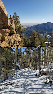
When I came to the big rock outcropping above the falls, I figured I'd scramble up the side and grab a view. Then it was back to the lovely, snowy trail in the fresh winter mountain air.


The snow underneath the trail did get thicker as I ascended. It became a little more challenging to find my footing, as I sunk in a little more with each step. 

I came quickly upon the crossing with the off-road vehicle road, FS #381. I had considered taking this way back down after the summit, but when I saw that the road was filled with completely untouched snow, I decided against it. My nanospikes are great for pre-packed trails, but not helpful at all for post-holing through untouched trails.

After the Mt. Rosa route crosses FS 381, it turns off quickly to the west and ascends toward Rosa's big, flat northern saddle. This part of the climb was slow but steady until I reached the saddle.

At the saddle, I was instantly greeted by awesome views to the west and north. Mt. Rosa's taller western neighbor, Almagre, was in full view, with the south face of Pikes Peak to the north.

Panorama from the saddle below Mt. Rosa's summit.

It was after this point when I encountered the truly deep snow. The wind kicked up and chilled me right through, but I was determined to press on.

I kept stepping through the drifts, sinking in to my mid-calf on every step. This would be a slow half-mile to the summit. Suddenly, the drift gave way, and I was up to my hip in snow. I pulled my leg out and tried again. I took three steps, then broke through again.

My fun-meter was getting quickly depleted.

Between the relentless wind and the deep snow, I took a look at Mt. Rosa's summit less than a half-mile away and decided it was not the day. Furthermore, I had the beginnings of a headache. I surmised that it was likely an effect of being over 11,000 feet. Although extremely rare for me, headaches can happen to anyone at higher altitudes, without any real reason.

If I had pressed on, it would have been an extremely slow half-mile. 

Time to know my limits and turn around!

Mount Rosa had eluded me again! I was reminded of a few years ago, when Bailey and I had done the Mount Rosa "standard loop" and been within a few hundred feet of the summit when deep snow turned us back.

Even though I've stood atop Mount Rosa's summit at least a half-dozen times, today would not be one of those times.

Instead, I had a short break at the saddle and took in the view of Almagre and Pikes Peak. I opened my PeakFinder app on my phone and saw that Longs Peak was visible to the north on this clear day. I could make out its distinctive ridgeline in the far distance. 

However, after only a few minutes, my fingers were getting frozen, even with gloves on. I knew I'd feel better after I descended from the saddle, since the wind is always far worse on this exposed ridge.

I returned to the junction and took trail 672 down towards Frosty's Park. I immediately felt that going this way was the right decision. 672 was well-trekked in, and I was making excellent time on the downhill in the soft snow.

Soon I arrived at Frosty's Park, where I took a few minutes to soak up the very warm sun in the wind-free mountain meadow.

Top: Trail 672 was a snowy playground! Bottom: The warm meadow at Frosty's Park. 

Fortunately for me, just this short descent totally cured my headache, so much that I forgot I'd even had one.

I sat on a snow-free patch of grass and ate my snack that I'd intended to have at the summit - a sandwich made of two stroopwafles (the original Dutch ones) with natural peanut butter in the middle. So delicious! It was even better because it was still frozen from the cold air up top. 

I probably could have sat in that meadow all day! But I wasn't done yet - over half my mileage was remaining. Still, I was relaxed and warm, and I felt totally confident about the upcoming 14 or 15 miles of gentle downhill ahead of me.

I've mentioned it before, but my favorite format for a long run is a steep, rapid, rocky ascent to elevation, followed by a long, gradual, runnable descent - preferably on a dirt road or other smoothly-graded trail.

I had only the fun and relaxing part of my run ahead of me now, jogging down FS 379 to Old Stage Road and then back through the National Forest into town.

I'd done this part before, right at the end of November last year, and I'd had a peaceful, serene time. I was quite looking forward to this.

I was happy to see that the snow on FS 379 had been packed in by several vehicles. My nanospikes were perfect for the hard packed snow, gripping right in, even on the icy parts.

I looked back at Rosa, watching the half-moon rise above it.

As I reached Old Stage Road, I could see a clear view back towards Rosa. Her slopes looked so distant! It was hard to believe I'd just come from there.

Top: Half-moon rising above Rosa. Bottom: Glancing back, Rosa is now in the distance on the right-hand side.

A few miles down the road, I began to feel like I was entering a flow state. I was gliding easily over the patches of snow and ice with confidence. I thanked the universe for my opportunity to be here, and for my family, and their support and love.

I've been feeling so good lately that I am amazed, and a little perplexed. I can't remember the last time I've felt so strong both physically and mentally for so many weeks on end. Something is going right!

I will put a quick note in here about my "word of the year." I subscribed to the New York Times' "Well" newsletter at the beginning of this year, and one of the recommendations was to pick a single word that you can use to reflect upon during the year and help inform your actions. I picked the word consistency. This word has served me well already. I am eating a large salad nearly every day, and maintaining my weightlifting workouts. Perhaps the real reason I feel so good lately is consistently trying to practice healthy habits.

I know that we all go through ups and downs in life, and I'm thankful that I've found this place of contentedness. I am hopeful that I can reflect on moments like these when I am faced with hardships in the future.

Back to the run - I continued downhill, bypassing many interesting rock outcroppings and views. I looked at the rock faces and tried to see reasonable ways to climb up them. I imagined what wonders their summit views might hold.


Soon I'd reached Devil's Slide, which is a long, smooth rock on the north side of the road.

Devil's Slide. 

Just around the bend was the parking area for St. Peter's Dome.


And then my favorite part began! After passing the Dome, the road begins to descend more steeply, entering a fairly deep canyon. The temperature immediately fell. Last time I ran this segment, I felt totally at peace. Today, I just felt strong. I was flying downhill easily.

I didn't take any photos during this section, primarily because I was so focused on the run, but also because it isn't the most photogenic segment.

But once I came out of the canyon, I had a great view back from where I'd just been. St. Peter's Dome was prominent in the fading light, as was Mt. Rosa.

Top: St. Peter's Dome is the pointy top on the left side of the photo, Mt. Rosa is the high point in the center. Bottom: Classic rock outcroppings near the National Forest border.

I tackled the small uphill section, passing by some of the classic jagged rocks that greet visitors who are entering the National Forest on Old Stage Road.

When I reached Penrose Blvd, my husband wasn't quite there yet to pick me up, so I ran the extra mile up to the gate at the zoo and back down, which is part of the course of the Run to the Shrine race that I've run in the past.

Between these extra two miles on the tail end, and the extra miles at the start of the day, I got just over 27 miles with almost 5500 feet elevation gain! A full marathon+ for my birthday - what a great way to celebrate another year in this existence, in this wonderful natural world.

I want to thank my husband and children for supporting me and giving me the day to let my spirit be free in the mountains. I also want to thank my parents, who brought me into this world 36 years ago and gave me the best upbringing and foundation possible.

And you, dear reader, thank YOU for taking this journey with me, it was quite a day!

***

Tuesday, February 1st, 2022:

A rest day after my long one in the southern Rampart Range yesterday!

***

Wednesday, February 2nd, 2022:

Back at it, with 35 minutes on the row machine first, then:

* Barbell back squats

* Standing chest fly

* Pushups - slightly elevated, gripping dumbells

I need to do core work soon.

***

Thursday, February 3rd, 2022:

* Dips

* Weighted calf raises

Then I just had to get out in the sunlight, post-snowstorm! The nanospikes that Alex got me a few years ago were quite perfect for the conditions. I did 5 and a half miles at Palmer Park, much slower in the snow, but so gorgeous. 

Going up the canyon - which I've run up many hundreds, if not thousands, of times - was a new experience with the powdery lovely snow surrounding me.


The panorama at the first overlook was awesome!

I stayed totally on trails within the park today, going up Grandview Trail all the way until the overlook, then taking the West Cheyenne Trail back down.


I enjoyed looking out at the snowy Blodgett Peak through the trees, especially considering how different the conditions are up there now, versus my long run just a few days ago.

***

Friday, February 4th, 2022:

Back to the park for another short one! Right about 10k, 6.2 miles. Snow conditions were still perfect for the nanospikes.


Then, at home, I did pushups and lying leg raises, to round out the day. 

***

Saturday, February 5th, 2022:

Morning gym workout was kettlebell lunges and sitting machine pulldowns. In the afternoon, I found time for leg raises in the yoga trapeze (engage the core!) And followed that with 30 minutes on the row machine.

***

Sunday, February 6th, 2022:

A mid-long run today, up through Palmer Park, Marconi Heights, and Austin Bluffs Open Space. 12 miles and 1800 feet.


It was a lovely day, even though the trails were basically hard-packed ice with a bit of snow on top. My nanospikes were perfect 👌 for the conditions.

I looked up at Mt. Rosa and felt her calling me, I'll be (hopefully) seeing her soon!!

***

Monday, February 7th, 2022:

A rest day, and catching up around the house, in anticipation of a big one tomorrow!

***

Tuesday, February 8th, 2022:

A long one for my birthday! However, since this post is already getting a little bit lengthy, I am going to do a separate post for my birthday run. Look for it in my next update (soon)!

Tuesday, February 1, 2022

Garden of the Gods, Standley Lake Regional Park & A Redo of the Blodgett-to-Rampart Crossover

***

Saturday, January 29th, 2022:

When I saw how warm the weather was today, I knew I had to get some mileage in! I also really wanted some lovely pictures, and I decided I'd head for Garden of the Gods. 

I ran on Rock Island Trail to Monument Valley Park, then through Sondermann Park/ Mesa Open Space.

I ran into the Garden near High Point and was immediately greeted by the picturesque formations. 


A tank-top day in the winter!

I enjoyed the visual effect of the snow filling the cracks on the red rocks with the peak in the background.

Rock formations near High Point Overlook.

Although there's still plenty of snow in the mountains from our last snowstorm (which I happened to get to run in at Palmer Park), the Garden of the Gods is almost melted off totally from the warmth in-town.

I sat atop one of the rocks and got an amazing panoramic view. I took a few minutes to relax and eat a granola bar and drink some Gatorade. I loved looking at all the wintery mountains and the rest of the Garden below.


I wish I could have stayed for longer! It was time to head home. Last time I did a run to the Garden of the Gods, I netted 20 miles. But I didn't really want to go that far today, so I took a little bit shorter route back rather than making a big loop, and still got over 16 miles.

What a warm bluebird day! I ran in a tank top almost the whole time. 

***

Sunday, January 30th, 2022:

My morning workout was a lot of barbell deadlifts and heavy dumbbell curls. 

Then we took the children for a walk and some exploring at the Standley Lake Regional Park, near Westminster.

It was another 60-degree winter day. Gorgeous for us, concerning for the climate, but I digress.


North Arapahoe Peak and Kiowa Peak, both 13ers, are snow-capped in the distance.


This cute regional park features lovely grassland-area trails with views of the distant 13ers and 14ers, and a fairly large lake with boating in the summer, so we may have to go back then!

***

Monday, January 31st, 2022:

Officially my first time in the mountains this year! Actually, since the end of November when I did a Mt. Rosa circumnavigation (semi)-loop.

Two months in town has been lovely, but I jumped at the opportunity to do a long one with no pavement, sidewalk, or asphalt!

This run was sort-of impromptu. I had the time, and the weather was great, and I really wanted to get a run in before the huge snow we are expecting. I wasn't going to go "that" far since I did 16 miles two days ago, and then a ton of deadlifts just yesterday. But plans change!

Originally I was planning to go to the Bear Creek Canyon area, but when we left the house the sun was shining so brightly on the south hills of Blodgett Peak Open Space that I changed my mind.

The south-facing hillsides were completely bare of snow and I figured it would be a warm and lovely day to go out to Rampart Range Road from Blodgett. I knew that it meant tackling about 21 or 22 miles though! I'd brought enough supplies for a run of that length, so I decided to just go for it.

I've done this run once before, in mid-October last year. That day was it real fall weather in Colorado; I got graupel, snow, and wind. I also started at S. Blodgett and did a fair amount of bushwacking when I lost the trail at an outcropping. 

Today, I decided to try this route again from the  main Blodgett Peak Open Space, and try not to lose the trail!!

A bit of cloud cover came in as I first began, but it was a lovely winter day. I immediately was able to connect to the main trail that I was looking for, heading up into the National Forest towards Ormes Peak from Hummingbird Trail.

Top: Blodgett Peak view from the start of the trail; Bottom: Frozen waterfall on the National Forest trail above Hummingbird Trail. 

The trail left the main open space very quickly, and became a much steeper National Forest trail. I passed by a lovely frozen waterfall, and climbed up the class 2 terrain.


Soon, the clouds began to clear and I got a sunny view of Blodgett Peak to the north.


The trail had small amounts of snow in the valleys and north-facing parts. But it was soft powder snow and not icy at all, so I didn't put spikes on (although I brought them just in case.)


The views down into town were amazing as I crested the first ridge. This trail was great, a lovely steep trail that felt like going up the 16 Golden Stairs on Pikes at times. 

The rock outcroppings were beautiful, even as I got into the thickest part of the burn area.

Overhanging rock in the distance... I'll be back!

Note the big rock outcropping in the bottom photo. I plan to come back here and climb that, and stand on that little overhang. 

I was above the highest ridge and on a little downhill section when I came back to the rock outcropping where I lost the trail last time.

Once again, as I approached the outcrop, I couldn't seem to find the right trail. A little perplexed, I backtracked a short way and still it eluded me.

I trended down but towards the north this time, and I was saved by the snow! After a (very short) bushwack downhill, I found the trail. I could make it out much more easily now that I could see footprints in the snow.

Another short downhill section of now easy-to-follow trail to the north, and just like that, I was at the 4-wheel road that encircles Ormes Peak.


The trail past the highest ridge through the snowy forest, and a fire-scarred tree trunk.

I saw the cairn from last time that goes up the true summit of Ormes, but I wasn't planning on doing that side trip today. I do want to come back and do a full Ormes summit trip when there's less snow on the ground and warmer weather. In fact, I'll probably plan a rock-outcropping-hopping adventure in the future and include Ormes.

Now that I was at the road, it was covered in several inches of powdery snow. It wasn't awfully deep and it was just slightly crunchy on top, perfect powder for running in.

I saw one set of footprints of someone who'd been here since this last storm, but I hadn't seen a person all day. Perfect quiet winter woods. I took a lot of photos along road #303 as I jogged toward the "main drag" of Rampart Range Road #300.


Looking back at Ormes Peak from Road #303.

Road #303.


Pikes Peak comes into view in full splendor on road #303.

Pikes Peak came into full view. It was at this point that some wind gusts came upon me, super strong and already indicative of the cold front that would be pushing into town later tomorrow evening. There's nothing like an icy winter wind! The sun was so warm though, and the wind so spontaneous and impersistent, that I immediately warmed back up.

I spent some time contemplating life and being thankful for this moment and my life experiences. I prayed for friends and family. The Rampart Range was quiet and peaceful, sunny yet cool, and the perfect trail church.

Before I knew it, I'd reached Rampart Range Road #300. I considered this the "easy remainder" of the run, 14ish miles of mostly-downhill.

300 was completely clear down to the dirt, but I didn't see any traffic.

When I approached the Eagle Lake Overnight Camp a mile or two down the road, I saw why. The road had only been cleared to that point and it was a complete snowdrift beyond that. The gate must be closed at Balanced Rock. I'd have the rest of the way to myself, but I'd have some snow to contend with.

Bottom: Rampart Range Road after the Eagle Lake Camp was filled with snow, and one set of footprints. 

There was one set of footprints that were tracked all the way along the road in the snow, going in the opposite direction (from GoG to Rampart). If I had to guess, I imagined they were probably Craig Burbank's. He's the only other individual I knew personally who would be crazy enough to go this far in the snow on Rampart Range Road!! (Well, maybe crazy ultrarunner Bob, but more likely Craig.) I was impressed when he told me he sometimes did the road all the way to Woodland Park twice a week.

As I was going uphill before the overlook, a HUGE gust of wind kicked up a snow drift in front of me. I saw it coming and turned around, the wind almost knocking me over it was so strong! I felt determined, relaxed even. I had the right attitude for this run - it was going to be a great day, I was going to feel great the whole time, and nothing could stop that. 

Soon I'd arrived at the overlook and now everything from here on was all downhill!

Some views from the overlook.

The long downhill was gradual and I felt good still, so I kept going at it. The sun was shining and the snow was mostly melted from this point on. I was quite glad that there were no vehicles.

As I went downhill, so did the sun, traveling on its long arc towards the western horizon, making the shadows long and bathing the foothills and canyons in dramatic light.

Top: The high point along the ridge with the jutting-out rock looks like the same rock I saw on my way up. 


At this point, looking towards the north, I spotted an overhanging rock outcropping that I believe is the same one that I saw in the National Forest on my way up from Blodgett, that I had sworn to return to.

Lower down on the road, all the snow had melted away. I jogged casually and comfortably downhill, spotting familiar landmarks in the distance, like the noticeable bluffs of Palmer Park, Austin Bluffs, and Pulpit Rock. I felt great! I was coasting along and barely felt like I had over 20 miles on my legs, despite heavy deadlifts yesterday, and despite 16 miles the day before that. I pondered how this was possible, but I was mostly just thankful. Thankful that my body could take me this far and feel this good; thankful for the opportunity to explore my world; thankful for the present moment.

I finally reached the Garden just after the sun went behind the mountains.

Top: The near-sunset light on Queen's Canyon, with Austin Bluffs below and beyond. Bottom: This rock outcropping indicates an arrival in the Garden of the Gods, just one turn up Rampart. 


I ended up with 23 miles, and 5300 feet elevation gain. And I gained a lot of confidence! Maybe mostly mental, but I didn't let my cumulative fatigue overcome me, and I felt strong all the way through until the end.

Now I can stay home for the next few days as the cold front and snowstorm come through, focusing on resting and cross-training.

If you made it this far, thanks for reading! I realize this was a long one. I wanted to document it in great detail so that I can look back and draw inspiration from my experience, realizing that we are all capable of much more than we expect!