I'm always looking for times when trails are empty. Additionally, I use my buff as a face mask in case I do come across anyone on the trails. Without further ado, I'll share the places we have been checking out this last month.
***
On April 30th, we toured the South Platte River corridor on our way north, stopping briefly to check out the rushing river.


We soon ended up in the small town of Bailey, CO, near the north entrance to the Lost Creek Wilderness. I started my run from the north trailhead for the Brookside-McCurdy trail. I really wish I had more time to explore this place! I made a little over 9 miles (out and back) on the winding, woodsy trail that serves as an access point for the Lost Creek.


This trail in particular was quite a climb, and I reached 9500 feet before I had to turn around. There were still some pretty large snow patches as I got higher up. The Lost Creek Wilderness is filled with tall aspens and distant views.


I'm hoping to be able to return to this trail for a longer run sometime this summer. Due to our late-in-the-day timing, I only passed three hikers in the first mile on this run and saw no one else the whole time.
***
On May 4th, we went to Chatfield State Park. This large reservoir sits just south and west of Denver. Since this was a Monday, it was relatively quiet compared to other times of the week. I circumnavigated the whole reservoir on the paved path. It was a somewhat windy day, but the sun was out and I got really sunburnt! A reminder that the Colorado summer sun is already upon us.
I was very happy to complete the whole 11.4 mile loop, with awesome views of the res below when running across the dam.


***
On May 8th, we went to the Rocky Mountain Arsenal National Wildlife Refuge, northeast of Denver. There are several parts to this refuge, including a bison area (no foot trails in that part of the refuge!)

First we looked at the bison, then I ran a short 6 mile out-and-back on the lovely trails (not in the bison area.)
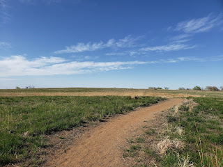
Then I hiked with Alex and the kids a little more (bonus mileage!)

Then we drove the wildlife loop (one way drive) as the sun was setting, seeing plenty of deer, rabbits, and antelope.


***
On May 12th, we made another return trip to Columbine Open Space. This quiet single-trail open space near Larkspur has been a good place to go on evenings when there aren't many people out.
This time, I made exactly 10 miles by running to the Frink Creamery Trailhead and back.


I never saw another person this day. Even the Frink Creamery Trailhead was empty.
***
On May 16th, Alex took me to the eastern Rock Island Trail outside of Falcon, CO, and dropped me off for a 10 miles out-and-back towards Peyton. This was an interesting evening, as storms lingered over Colorado Springs, but I avoided any rain where I was running.
I crossed the Historic Black Squirrel Creek Bridge midway through the run.


Although really flat, this run was challenging for me.
***
On May 20th, I set out at sunset at Spruce Meadows Open Space. I got a couple sunset photos, but soon the stars were out. Amazingly, the night was so clear that I could almost, but not quite, see the milky way. It was very windy, and this probably contributed to the clear air and open skies.


I made 7 miles on that clear and windy night.
***
Finally, last night, May 23rd, I set out late from Spruce Mountain Open Space. The last car was just leaving as we arrived, and I had the nighttime trails to myself.


I ran an 8 mile loop, which I'm counting as this year's Memorial Weekend run.
***
It's been an interesting month! As it rains and pours right now, and we can expect snow in the mountains again tonight and tomorrow, I ponder what else this summer might bring as far as social distancing runs.
I'm thankful that I've been able to see new places and get some time in the outdoors this past month. I have a few big ideas for longer runs for this summer, which may or may not happen. But at least I can dream!!
Keep dreaming, friends. And stay safe out there, so I can see you all out on the trails again!


This trail in particular was quite a climb, and I reached 9500 feet before I had to turn around. There were still some pretty large snow patches as I got higher up. The Lost Creek Wilderness is filled with tall aspens and distant views.


I'm hoping to be able to return to this trail for a longer run sometime this summer. Due to our late-in-the-day timing, I only passed three hikers in the first mile on this run and saw no one else the whole time.
***
On May 4th, we went to Chatfield State Park. This large reservoir sits just south and west of Denver. Since this was a Monday, it was relatively quiet compared to other times of the week. I circumnavigated the whole reservoir on the paved path. It was a somewhat windy day, but the sun was out and I got really sunburnt! A reminder that the Colorado summer sun is already upon us.
I was very happy to complete the whole 11.4 mile loop, with awesome views of the res below when running across the dam.


***
On May 8th, we went to the Rocky Mountain Arsenal National Wildlife Refuge, northeast of Denver. There are several parts to this refuge, including a bison area (no foot trails in that part of the refuge!)

First we looked at the bison, then I ran a short 6 mile out-and-back on the lovely trails (not in the bison area.)

Then I hiked with Alex and the kids a little more (bonus mileage!)

Then we drove the wildlife loop (one way drive) as the sun was setting, seeing plenty of deer, rabbits, and antelope.


***
On May 12th, we made another return trip to Columbine Open Space. This quiet single-trail open space near Larkspur has been a good place to go on evenings when there aren't many people out.
This time, I made exactly 10 miles by running to the Frink Creamery Trailhead and back.


I never saw another person this day. Even the Frink Creamery Trailhead was empty.
***
On May 16th, Alex took me to the eastern Rock Island Trail outside of Falcon, CO, and dropped me off for a 10 miles out-and-back towards Peyton. This was an interesting evening, as storms lingered over Colorado Springs, but I avoided any rain where I was running.
I crossed the Historic Black Squirrel Creek Bridge midway through the run.


Although really flat, this run was challenging for me.
***
On May 20th, I set out at sunset at Spruce Meadows Open Space. I got a couple sunset photos, but soon the stars were out. Amazingly, the night was so clear that I could almost, but not quite, see the milky way. It was very windy, and this probably contributed to the clear air and open skies.


I made 7 miles on that clear and windy night.
***
Finally, last night, May 23rd, I set out late from Spruce Mountain Open Space. The last car was just leaving as we arrived, and I had the nighttime trails to myself.


I ran an 8 mile loop, which I'm counting as this year's Memorial Weekend run.
***
It's been an interesting month! As it rains and pours right now, and we can expect snow in the mountains again tonight and tomorrow, I ponder what else this summer might bring as far as social distancing runs.
I'm thankful that I've been able to see new places and get some time in the outdoors this past month. I have a few big ideas for longer runs for this summer, which may or may not happen. But at least I can dream!!
Keep dreaming, friends. And stay safe out there, so I can see you all out on the trails again!


